We specialise in geodetic engineering, including but not limited to, topographical surveying, site engineering, laser scanning, monitoring, survey control network establishment and maintenance and surface geometry analysis.

About us

GEO-PRECISE LTD is a small and agile civil engineering company covering projects in the UK and the EU. We based our business on more than 35 years of experience, that we have gained being involved in 250 linear miles of topographic surveys, hundreds of miles of railway and highway construction and 5M ft2 building and open space developments in the UK and in the EU, totalling of more than £3 billion in value, including major projects like HS2. Our engineers worked with numerous clients and main contractors such as Environment Agency, Network Rail, Transport for West Midlands, Fitzgerald Contractors Ltd, Rockland Concrete Ltd., TSL, Buckingham Group, Plowman Craven Ltd, AMEY PLC, BAM Construction, Winvic Construction, FM Conway, Moortown Group Limited and JB Riney highlighting a few.

On our projects we care about quality and professional reliability the most, using a creative and adaptive mindset to succeed through all kinds of challenges, and to keep our environment safe and healthy.

Services

Topographical Surveying

Topographical surveys determining the three-dimensional position, of natural and man-made features on or beneath the surface of the Earth. These features may be represented in analogue form as a contoured map, plan or chart, or in digital form such as a Digital Ground Model.

Either or both of the above formats may be used for planning, design and construction of works.

Setting out

In engineering the production of an accurate large-scale plan is usually the first step in the planning and design of a construction project.

Thereafter the project, as designed on the plan, must be set out on the ground in the correct absolute and relative position and to its correct dimensions, using a Total Station or GPS for 2D and 3D setting out, or maybe a Level for vertical positioning only.
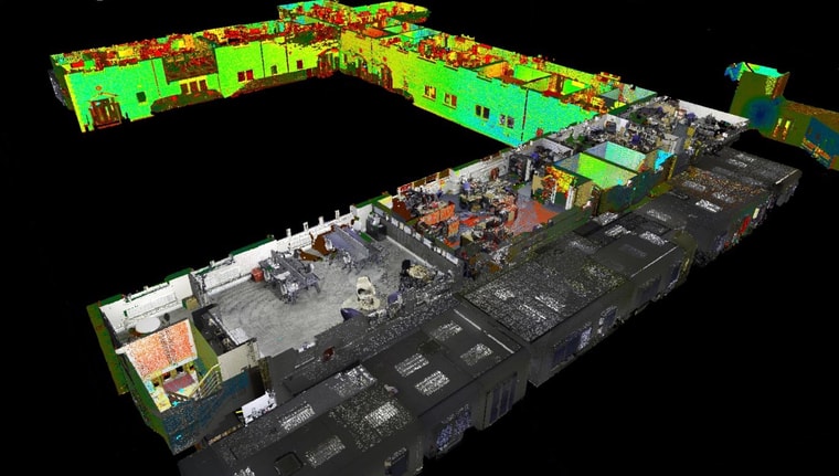
Laser scanning

Laser scanning is the process of analysing a real-world environment to collect data on its shape and its appearance. It can be used along with (or as a complete alternative to) conventional survey methods.

It collects a large amount of data over a short period of time. The collected information transforms in the form of point cloud data, which than can be used to construct maps or digital 3D models.

Monitoring

Monitoring surveys are a precise method of surveying where structures or features, such as railway tracks, bridges, retaining walls or embankments, which are thought to be moving or have the possibility of moving are repeatedly checked to determine the amount of movement or deflection, in 3D, on the level of millimetres if required.

Survey Control Networks

Control survey provides a framework of survey points, in two or three dimensions, to specified degrees of accuracy. The areas covered by these points, form the basis for maps.

The methods used for establishing and maintaining control networks are: Traversing, levelling, GNSS position fixing and network adjustment calculations, such as least square estimation.

As-Built Surveys

Most of the surveys are carried out before the actual construction, but as-built surveys are showing the state of a site at a particular point during or after the works, as well as recording any variations from engineering plans provided and verifying contract compliance.

These types of surveys are usually presented in digital format as a CAD drawing or as a list of coded coordinates.

Volumetric Surveys

Volume measurements are essential in many different processes of a construction, such as earthworks, concreting or asphalting, to provide an independent measure on the quantity of materials.

Whilst most volumetric surveys are done by conventional survey methods, larger scale surveys (e.g., opencast mining) are often carried out using terrestrial or aerial laser scanning or photogrammetry.

Surface Regularity Surveys

Surface profiles of industrial concrete floors must be controlled so that departures from theoretically perfectly flat plane are limited to an extent appropriate to the planned use of the floor.

Engineering supervision during concrete pouring can minimise surface irregularities, whilst surface regularity surveys are verifying compliance with the relevant floor classification standards.

What we offer:
High Quality Engineering • Professional Dedication • Adaptive Approach • Technical Reliability • The latest technology • Professional Indemnity up to £1 000 000 • Public Liability up to £5 000 000 • Certified Management System - ISO 9001:2015

Team

Bence Pintye, managing director
Bence Pintye
Managing Director
Laszlo Jank, technical director
Laszlo Jank
Technical Director
Andras Bodoczi, executive director
Andras Bodoczi
Executive Director
Nora Kardos, project manager
Nora Kardos Pintyene
Project Manager
Aniko Kmetz, data administrator
Aniko Kmetz
Data Administrator

Projects

Floor flatness, Łódź (PL) – Surface Regularity and Grinding report

In March 2024 we received a request from a Polish company for a 10,000m2 concrete warehouse floor evaluation, through MATMAP SURVEY Ltd. We have successfully delivered the reports, for both the initial and control surveys, within 24 hours from receiving the registered point cloud data, using GEO-PRECISE Ltd.’s inhouse surface geometry analysis software, Flat4.

Our Surface Regularity Reports (pdf) contain essential statistical records of the floor geometry to recognise deviations that are occurring during different stages of the construction. The documents also include custom scale engineering maps for each type of errors for easy visualisation, as well as detailed AutoCAD files and coordinate lists to help the grinding team locating the errors on site.

Grinding plans are also produced on request, based on a digital grinding sequence through multiple iterations, targeted to ZERO errors.

Floor flatness, Łódź (PL) – Surface Regularity and Grinding report

Coleshill West Viaduct – Site and Quality Engineering

We were approached by J. Carney Construction Ltd. in August 2023 to participate in one of UKs most prestigious railway construction scheme in the Midlands.

Two GEO-PRECISE engineers are responsible for the construction of four, 660m long, precast segmental viaducts near Coleshill town in North Warwickshire. The 2-year project covers the construction of the entire substructure, with 3 bridge abutments and 55 piers from pile caps to pier heads and bearing plinths.

Our role is to deliver setting outs, as-builts and to keep all the quality reports up to date, as well as to provide technical supervision for steel reinforcement- and framework installation, concrete placement and for the positioning of span and bearing elements according to the given standards.

Coleshill West Viaduct – Site and Quality Engineering

Fitzgerald Contractors Sites – Site Engineering

After becoming an approved subcontractor for Fitzgerald in 2021, GEO-PRECISE Ltd has been involved in successful infrastructure projects as site engineers at the following sites.

Evesham Cycle Facility (Pictured above) • Coventry Rd, Cawston • Tollhouse Way, Smethwick • Gallows Hill, Royal Leamington Spa • Oakley Grove School, Royal Leamington Spa • Marketplace, Shepshed • MIRA Interchange, Nuneaton • Knights Lane, Stratford-upon-Avon

On every site engineering project, our participation starts with the thorough checking of the construction drawings before the actual work begins. Then we constantly provide setting out services, as-built surveying, QA checking and documentation, reviewing and interpretation of drawing updates, delivering volume calculations as well as fulfilling site management duties through each project.

Fitzgerald Contractors Sites – Site Engineering

Amazon Robotics Facility – Setting Out

Throughout 2021 and 2022 GEO-PRECISE Ltd have been involved in the installation of robotic floor equipment on 18 floors in 6 different Amazon warehouses (each of them is over 1.5 million square foot) across the UK as part of the setting out team. Our task was to position thousands of points every week on each floor, keeping 3mm accuracy across the whole site, whilst successfully cooperating with several other construction teams, to be able to deliver within scheduled time.

Amazon Robotics Facility – Setting Out

Seymour Leisure Centre - Measured Building Survey

In August 2022 a small team of GP engineers carried out a Measured Building Survey of a building complex in the City of Westminster, counting a large state-of-the-art gym, a 30m swimming pool, a 4-story indoor climbing wall and several other gyms and spa rooms, as well as a labyrinthine basement and engine room. The project also included the installation and traversing of a new control network and the survey of the elevation and surrounding of the buildings and capturing large part of the roofs. Liaising with the local property management team, GP delivered the site surveys in less than 5 days, whilst keeping the relative accuracy within the given 6mm tolerance.

Seymour Leisure Centre - Measured Building Survey

A12 and Whalebone Lane Junction - Topographical Survey

At the end of October 2021 GEO-PRECISE LTD participated in a highway scheme of Transport for London and delivered a 1.5 km long topographical survey from a frequented junction of the A12 Eastern Avenue.

Combining terrestrial laser scanning with conventional Total Station and GNSS observations, our team has managed to safely complete a detailed 3D survey of the entire area in 4days, to 8mm relative accuracy, including all central reservations and a 2m grid road surface model within 20m of the crossing itself, with NO traffic management involved, but maintaining all H&S regulations.

A12 and Whalebone Lane Junction - Topographical Survey

Melbourn Science Park - Measured Building Survey

Two weeks before Christmas 2021 GEO-PRECISE LTD had the opportunity to take part in a large-scale property development plan, as the team carrying out interior surveys on all 9 buildings of Melbourne Science Park near Cambridge.

Working closely with the local facility management team, our engineer completed the works with a total of 950 scans during 11 site days, despite the complexity of the buildings and limited access to certain areas. The final point clouds were all related to OS Grid and were coordinated from a previously installed control network, maintaining a registration limit of relative 6mm through each building.

Melbourn Science Park - Measured Building Survey

Birmingham Infrastructure Projects

From February 2021 GEO-PRECISE LTD is providing Engineering services for multiple infrastructure projects in and around Birmingham through main contractors. Our engineers on these projects are fulfilling various duties like Site Engineering, Site Supervision or QA Engineering.

Project Sprint Highway (Fitzgerald Contractors Ltd): - Bus priority corridor, from Walsall to Solihull and Birmingham Airport. Beside general site engineering, supervision was one of the many tasks of GP’s engineer on this project, including quality documentation (ITPs), holding H&S Briefings, coordinating gangs and liaising with the Client.

Project Sprint Bus Stops (Transport for West Midlands): 95 distinct and high-quality bus shelters are being installed along the Sprint corridor. One of our engineers is responsible for coordinating utility diversions, producing reports to the utility team, managing communication between the designers and PC and the Sprint team members, making sure everybody has the information they need in a timely manner.

Pershore Road Highway Safety Improvement (Fitzgerald Contractors Ltd): Since November 2021 GEO-PRECISE LTD is providing a Site Engineering services on this scheme of Birmingham City Council, Improving the junction of Pershore Road, Priory Road and Edgbaston Road, constructing a cycle route between A38 Bristol Road and Cannon Hill Park.

Birmingham Infrastructure Projects

Lidl Luton Distribution Centre

Working on behalf of TSL, GEO-PRECISE LTD was involved in the construction of Lidl's largest (1.2 million ft2) warehouse as part of the Site Engineering team for 6 months. Working directly under the project management, our engineers were carrying out various tasks from the piling and foundation works, through controlling concrete and tarmac surfacing, and different parts of the structural construction, like erecting lift shafts and setting out external walls. Also delivering as built drawings from different stages of the construction on weekly bases.

As part of the same project, simultaneously with the site engineering works GEO-PRECISE LTD provided QA Engineering services to Kocher Regalbau Gmbh for the installation of 200+ anchor boxes. Checking and reporting the 3D location of the boxes between the installation and the concrete pouring and delivering post pouring as built drawings after the completion of each slab.

Lidl Luton Distribution Centre

G-Park Stoke on Trent - SR Comparison Survey

August 2021, GEO-PRECISE LTD has undertaken an FM2 Surface Regularity Survey (according to TR34 standards) on 12000 m2 concrete warehouse floor, at Stoke on Trent, upon Rockland Concrete Ltd.'s request.

During this project we produced two separate SR reports for the same area to compare the conventional floor surveying method, using precise level and digital surface profile recording device, against high precision 3D terrestrial laser scanning combined with our own surface geometry analyser software called Flat4 (comparison study is available here).

With the most up to date laser scanners and our self-developed survey method, we can keep the registration accuracy bellow the millimetre to be able to detect as small surface deviations across thousands of square meters as 0.1mm.

Each survey methods took 2 site days to complete, and the SR reports were produced on the following day.

G-Park Stoke on Trent - SR Comparison Survey

Coventry Station Redevelopment

One of GEO-PRECISE LTD's Site Engineering project in 2021 was at Coventry Railway Station. The project involved the construction of a new footbridge, station building, car parking, and a bus interchange.

From January until July we a have provided engineering services for mainly the external works such as drainage and surface paving for carparks and footways, including interpretation and reviewing of design plans, setting out and as built surveys.

Coventry Station Redevelopment

Industrial concrete flooring in Germany

Munich, Germany: Between August and October 2020 as a contractor for Malin Industrial Concrete Floors Ltd, GEO-PRECISE LTD was responsible for controlling the surface regularity over the pouring of the internal concrete floors, totalling of 96.000m2 on 3 levels.

Dortmund, Germany: Upon Rockland Concrete Ltd.'s request, GEO-PRECISE LTD carried out engineering supervision during the construction of high spec flooring of a warehouse near Dortmund. The work took place on over 11 000m2 newly built mezzanine floor in an existing distribution centre.

In both projects our engineering service covered full time assistance of the concreting team, using Live Tracing method on fresh concrete surface, as well as the establishment and the maintenance of the requisite control network. According to the construction management on both site, one of the key reasons of the successful outcome, was the outstanding way of professional communication that our engineers maintained between both the management and the operational team on site.

Industrial concrete flooring in Germany

Brooklands Link Road, Magna Park (Moortown Group Limited)

Working with Moortown Group between 2020.06-2020.09, our company was involved in a 550m road construction, linking the main road with a newly built warehouse. Throughout this short period, we successfully participated in installing a 30x10x7m culvert, casting parapet reaction slabs and laying kerbs, drainage and underground services.

Brooklands Link Road, Magna Park (Moortown Group Limited)

Pannatoni Park and Mountpark Bardon 2 (Winvic Construction Ltd.)

On these projects we worked on 7 units all together between July 2019 and February 2021. Pannatoni Park was a £43m development on 623.000 SQ FT near Northampton, whilst Mountpark Brandon 2 totalled £40 and included 579.000 SQ FT distribution space in Coalville.

On both projects our main task was to work in cooperation with the sub-contractors responsible for the dock-, external- and internal slabs mainly, while recording and keeping the quality assurance paperwork up to date. Regularly helping with foundations, drainage, pump station, roads, underground services and holding down bolts.

Despite having a tight schedule, we managed to lay the yard slabs in time without defects thanks to the cooperation and communication between our engineer and the site team.

Pannatoni Park and Mountpark Bardon 2 (Winvic Construction Ltd.)

A38 Birmingham Cycle Revolution (AMEY PLC)

In January 2019 GEO-PRECISE LTD started a new contract and joined an ongoing £5m redevelopment of a 4km long section of A38 in Birmingham and constructing a new cycle lane. Daily duties included the setting out for civil works, controlling plane-offs and surfacing for different sub-contractors, while also liaising with Birmingham City Council and designers.

A38 Birmingham Cycle Revolution (AMEY PLC)

Southall Waterside (FM Conway)

Over 2 months in 2018, GEO-PRECISE LTD taken part in FM Conway's development scheme of 618 new homes and seven acres of outdoor space. Engineer for the main contractor, allowed us to be involved in nearly every aspect of works, including setting out and as-built survey of S278 works, slip roads, drainage, underground services and landscapes.

Southall Waterside (FM Conway)

St. Michaels' Catholic School (BAM Construction - Goldmax Ltd)

From 2018.05-2018.10. we successfully finished our contract for the £24m development of a newly built school. Working with a groundwork company, we were tasked with the setting out, as-built surveying and keeping track of the quality assurance of piles, beams, foundations, holding down bolts, drainage, underground services and internal slabs.

St. Michaels' Catholic School (BAM Construction - Goldmax Ltd)

Wildernesse House (MacPheadair Ltd)

GEO-PRECISE LTD participated in a successful £30m redevelopment and renovation project of a 14th century historical mansion on 24-acre estate in the Kentish countryside in 2017-2018. Our daily duties included the engineering assistance of road, drainage, underground services work, open spaces development and landscaping.

Wildernesse House (MacPheadair Ltd)
More projects

Our Clients and Suppliers

  • Fitzgerald
  • Carney Construction
  • G2 Survey
  • TFWM
  • BCL
  • TSL
  • Rockland

Contact us

222 Hillmorton Rd,
Coventry, United Kingdom
Map: 222 Hillmorton Rd, Coventry, United Kingdom